
Page 3 - June 2016 Issue 303
P. 3
JUNE 2016
THE NEW COUNTESTHORPE HERALD 3
HISTORICAL
Copyright of Turley.
This drawing is for illustrative purposes only and should not be used for any construction or estimation purposes.
DO NOT SCALE DRAWINGS.
No liability or responsibility is accepted arising from reliance upon the information contained within this drawing.
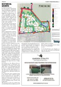
Masterplan Legend Site Boundary
Access - all modes
Access - pedestrian / cycle
Farm access
Existing public right of way
Proposed pedestrian routes
Primary Route
Secondary routes
Shared surface streets / private drives / mews
Key spaces / shared surface
Hedges proposed / retained Children's Play Area
Open Space (formal and informal) Residential Development Parcels Indicative built form
Potential for focal building Existing trees
Proposed trees (indicative)
SUDs feature
Client:
Catesby Estates (Developments) Ltd
Project:
Land off Leicester Road and Foston Road
Drawing:
Illustrative Masterplan
n
0 (1:2,000)
metres
100
GROWTH
Continued from front page
n 0 (1:2,000)
metres 100
Records show that Countesthorpe was essentially an agricultural village, the daughter settlement of Blaby. In 1066, its population was shown as six. In 1209, it was named ‘Le Thorpe’. As the population increased it became self-sufficient with its farmers, miller, carpenter and blacksmith for example, and as agricultural land was valuable, houses were confined to the centre of the settlement.
The landscape altered and the lifestyle of many of the villagers changed after 1767 when enclosure of the open fields began. Co-operative farming was replaced with competitive farming.
Where unemployment resulted, the manufacture of socks and stockings offered an initial solution. By 1801, the census shows a population of 540, and of these, 310 people were engaged in trade or manufacture.
As people became more mobile,
Scale:
1:2000 (A3)
Project Number:
CATQ3004
Drawing Number:
3200
Date:
13.05.2016
Status:
DRAFT
Revision:
B
the
n
u
m
b
e
r
o
Plans reproduced by permission of Ordnance Survey on behalf of The Controller of Her Majesty's Stationery Office. © Crown Copyright and database right [2013]. All rights reserved. Ordnance Survey Licence
n
0 (1:2,000)
metres 100
Plans reproduced by permission of Ordnance Survey on behalf of The
numb
er [1000
This drawin
g is for il
lustrativ
e purposes
only and
f Countesthorpe
Controller of Her Majesty's Stationery Office. © Crown Copyright and number [100020449]. This drawing is for illustrative purposes only and database right [2013]. All rights reserved. Ordnance Survey Licence should not be used for any construction or estimation purposes. Do
20449].
should not be used for any construction or estimation purposes. Do not scale drawings. No liability or responsibility is accepted arising from
residents increased and in 1961,
parish records show a population of 2,249. Despite efforts by residents to maintain both their village identity and the surrounding green belt, in 1988 permission was granted for a large housing development off Winchester Road. This trend has continued, and in many respects, Countesthorpe has become a dormitory village, where wage earners are generally only present outside of working hours. The 2011 census shows a population of 6,377 and in 2012 it is referenced as a ‘large village of some 7,000 inhabitants’. Mention should be made here of the increasing number of residents who are retired and the impact this has on village lifestyles.
According to the Blaby District Development Plan, Countesthorpe was scheduled for 520 houses in the period 2006 – 2029. As of 31st March 2012, 495 houses were completed and committed, leaving a residue requirement of 25. The goal posts obviously changed as it was deemed that additional housing was required.
In a recent letter sent to residents living in the vicinity, Turley of Bristol suggest that the proposed site “provides a logical extension to the settlement. It represents a sustainable location within walking distance of a range of local services including shops, schools and employment.”
The main access to the site would be from Leicester Road with a secondary access off
not scale drawings. No liability or responsibility is accepted arising from
reliance upon the information contained in this drawing
reliance upon the information contained in this drawing
Foston Road. New potential farm accesses
are proposed to the north-west and east of
t
quality of life for residents?
the site. Further details are available a
How will our developing society change
www.countesthorpeconsultation.co.uk The questions that need a considerable amount of thought now are: What are the implications for the future? Will there be an improvement or deterioration in the
Contr
the face of Countesthorpe?
Plans reproduced by permission of Ordnance Survey on behalf of The
oller of Her Majesty's Stationery Office. © Crown Copyright and
database right [2013]. All rights reserved. Ordnance Survey Licence number [100020449]. This drawing is for illustrative purposes only and should not be used for any construction or estimation purposes. Do
not scale drawings. No liability or responsibility is accepted arising from
reliance upon the information co
n
T
A
rue
ntained
in th
n
is drawin
g
Let the Herald know your thoughts we can voice the conversation and hopefully shape developments.
